Blue Marble
What would our perception of the world be if had we never seen images of the Earth taken from outerspace? NASA's first first images of the Earth were in black and white, transmitted from the Television Infrared Observation Satellite (known as TIROS).
The Apollo program (1963 - 1972) was designed to land humans on the Moon and bring them safely back to Earth. Six of the missions (Apollos 11, 12, 14, 15, 16, and 17) achieved this goal. The first full-colour images of the planet Earth were photographs taken by astronauts during the Apollo lunar missions.
In 1972, from a distance of about 45,000 km the crew of Apollo 17 took one of the most famous photos ever made of the Earth. This original, awe-inspiring "blue marble" image has given us the collective perception that our home is a singularly beautiful, blue planet that shines in contrast to the blackness of space.
There are 700 photographs which show the Earth in its near entirety from the Apollo program. Since then, NASA's space missions have produced a collection of over 750,000 images of the Earth's land surface, oceans and atmosphere which help us to better understand our Earth.
In 2002, NASA produced the Blue Marble, the most detailed true-color image of the Earth's surface ever produced. Using data from NASAÕs Terra satellite, scientists and data visualizers stitched together four months of observations of the land surface, coastal oceans, sea ice, and clouds into a seamless, photo-like mosaic of every square kilometer of the Earth. In October 2005, NASA released a new version of The Blue Marble with twice the level of detail as the original.
References
Apollo 10 (May 18, 1969)

This photo showing a view of three-quarter illuminated Earth showing Africa and Europe taken on the way to the Moon with a hand-held Hasselblad.
|

A view of the Earth from 36,000 nautical miles away as photographed from the Apollo 10 spacecraft during its trans-lunar journey toward the Moon. While the Yucatan Peninsula is obscured by clouds, nearly all of Mexico north of the Isthmus of Tehuantepec can be clearly delineated. The Gulf of California and Baja California and the San Joaquin Valley can be easily identified.
|

This photo of the Earth from the Apollo 10 lunar mission was popularized when it was published by LIFE Magazine.
|

Earth rising above the lunar horizon, an unprecedented view captured by the orbiting lunar module which came to within 8.4 nautical miles (15.6 km) of the lunar surface during practice maneuvers. The mission was the second crew to orbit the Moon.
|
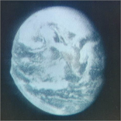
This view of Earth from about 12,800 nautical miles away is a color reproduction taken from the second TV transmission made by the color television camera onboard the Apollo 10 spacecraft. (PHOTO: nasaimages.org)
|
Apollo 13 (April 11, 1970)

When this picture was made, the Apollo 13 moon landing had already been cancelled, and the Apollo 13 crewmen were in transearth trajectory attempting to bring their crippled spacecraft back home. (PHOTO: nasaimages.org)
|
Apollo 17 (December 7, 1972)

View of the Earth as seen by the Apollo 17 crew traveling toward the moon. This translunar coast photograph extends from the Mediterranean Sea area to the Antarctica south polar ice cap. This is the first time the Apollo trajectory made it possible to photograph the south polar ice cap. This Apollo 17 image is likely the most widely distributed image of all time. (PHOTO: nasaimages.org)
|